Best Practice Guides
Explore the Ontario Dig Authority Best Practice Guides for up-to-date information.
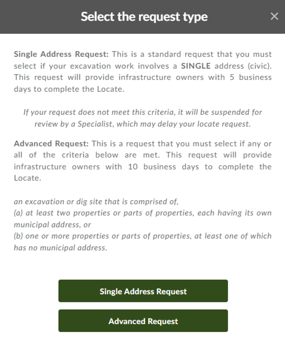
Advanced Request
Under a regulation effective May 1, 2024, Ontario Dig Authority differentiates between single-civic address locate requests and advanced requests (large excavations or dig sites). Single civic address locate requests have a deadline of 5 Business days, whereas advanced locate requests have a deadline of 10 business days.
What’s considered a large excavation?
A large excavation of a dig site is defined as:
at least two properties or parts of properties, each having its own municipal address, or
one or more properties or parts of properties, at least one of which has no municipal address.
How do I place a large excavation request?
If your work falls within the definition of a large excavation or dig site, click on “Advanced Request”. The request process remains the same.
Our Recommended Process
- Select the “Advanced Request” type when your proposed work will be occurring on at least two properties or parts of properties, each having its own municipal address, or one or more properties or parts of properties, at least one of which has no municipal address.
- Submit your Advanced Request at least 10 full business days prior to your intended start date of your proposed excavation. The Web Portal will now default to a minimum of 10 business days from your submission date.
- When making a map selection on a single address request, excavators are encouraged to be as precise as possible, as Single civic address requests are now limited to a single frame of the aerial imagery. If your map selection is too large for a single address request, a pop-up advising you of this will appear. You can either change your map selection or try making an advanced request.
- When submitting an Advanced Request, excavators are able to create multiple map selections over multiple frames of aerial imagery to provide more detail of their large project.
- Your locate request may be delayed if Ontario Dig Authority identifies it is in the incorrect category. You may also receive emails asking for clarification of the scope of your work. Ensure you either make the changes necessary for Ontario Dig Authority to process your locate request or contact us to discuss the request for clarification as soon as possible.
Automating 360 Feedback Responses
For Underground Infrastructure Owners (UIOs) who receive an average of 4 or more locate notifications per day, it becomes advantageous to automate their responses in 360 Feedback.
360 Feedback is the Ontario Dig Authority’s web-based solution used by UIOs to report the status of their locate response and by excavators to check the status of their request and find contact information for UIOs and Locate Service Providers.
Automated Software
There are two options available to automate the 360 Feedback responses
- Program your existing work management system, using our Web Service document, to respond directly to 360 Feedback
- Purchase software that will automatically update 360 Feedback, while also providing many other benefits to streamline your locate processes
PLEASE NOTE:
Should the Member decide to purchase software, they are responsible to make sure it correctly integrates with 360 Feedback
Contact our Education team to request the Web Service document or for a list of available Software Providers.
Changes To Information After Locate Response
What you need to know
Provided that a locate response is still valid, if an Underground Infrastructure Owner (UIO) becomes aware of any change in information that was provided, they must notify the following parties:
- Ontario Dig Authority
- The Excavator, if the information was provided for a standard locate under OUINS Act, Section 6 (1)
- The Project Owner AND the Dedicated Locator if the information was provided for a project involving a Dedicated Locator under OUINS Act, Section 7 (10)
When?
The parties must be notified of the changes within two business days after becoming aware of the change.
The UIO must provide Ontario Dig Authority with accurate mapping information within 30 calendar days of placing new infrastructure in the ground or removing infrastructure from the ground. (Rule 10 – Ontario Dig Authority Rules for UIOs and Excavators)
How?
- Contact Ontario Dig Authority
- Contact the Excavator – their contact information can be found on the locate request
Please note: A new locate request is not necessary. Once aware of any change, the Infrastructure Owner is responsible for updating the locate response.
Source OUINS Act, Section 9 (1)
Confirm Your Dig Location
The system compares the information you enter into the “Address Search” bar to the map selection(s) created. If you notice any incorrect information, such as an incorrect address, please make the changes before clicking “Next Step: Review”. If you find a discrepancy during the “Next Step: Review” section, you should select “Edit My Request” and make the required changes.
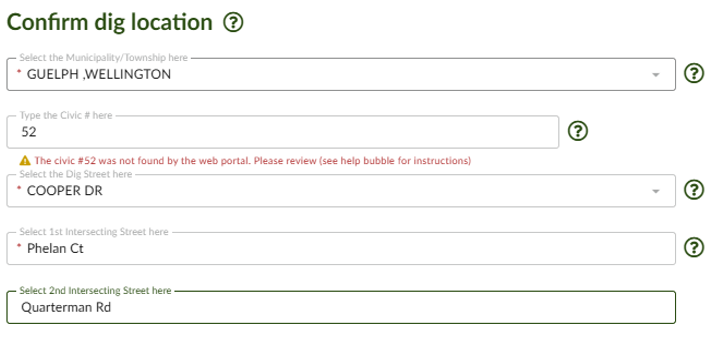
You know the proposed work area best! Our Customer support team reviews suspended requests to compare the “Dig Location”, map selection, and Additional Information submitted. If an agent finds a discrepancy, they will send a clarification email from “donotreply@ontariodigauthority.ca” requesting more information and/or a change to ensure you have valid locate paperwork.
Our Recommended Process For Confirming Your Dig Location
Enter the Address, Intersection or coordinates into the “Address Search”. Carefully select the location in the correct Municipality. You may need to search for a different version of the street name or use a number (e.g. Line Road 4 instead of Fourth Line).
**IMPORTANT STEP** After clicking “Next Step: Review” Carefully go over the details of your request including the “Confirm your dig location” section to ensure the information is accurate. Your map selections should be on or parallel to the “Dig Street” and the map selection(s) should be between the two closest intersecting streets provided.
**IMPORTANT STEP** If you find a discrepancy click on “Edit My Request” and make the necessary changes.
Why We Are Asking For This Information
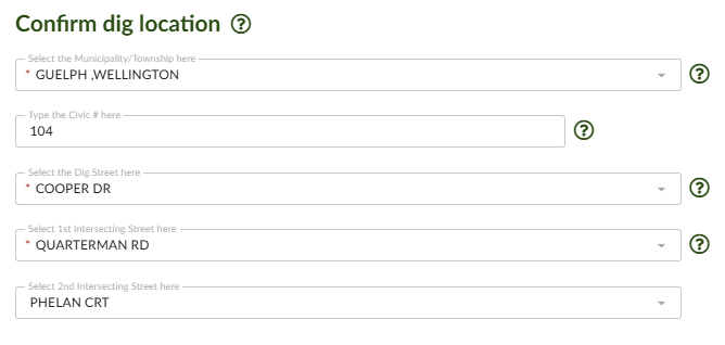
The information from your map selection and our internal system didn’t match up perfectly. We just need you to confirm that we got it right! If we didn’t, please help us out and fill out or correct the information in the fields under “Confirm your dig location” This section will also appear if you choose to “Edit My Request” from the “Review Page”, to give you the chance to correct the information.
Design & Planning Requests
Ontario Dig Authority offers a planning option for excavators who are not digging withing 30 calendar days.
Why Use Planning?
Planning saves time and money. Use properly submitted planning requests to organize the physical locates. Great for when you are expanding a project or planning landscape project.
Who Responds?
Underground Infrastructure Owners (UIOs) participate voluntarily, as this is not a requirement under the Act. UIOs that do not take part may be contacted directly for more information.
Where can you find assistance?
Contact the Ontario Dig Authority Support Services.
Our Recommended Process
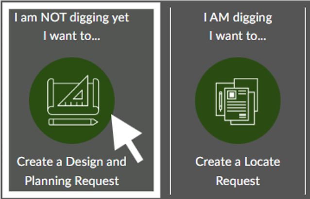
- Select “Create a Design and Planning Request” from the homepage.
- Enter the civic address(es), intersection, or coordinates into the “Address Search”.
- Create a map selection. You may only request one street per planning request.
- Your map selections should be on or parallel to the “Dig Street” and the map selection(s) should be between the two closest intersecting streets provided. If you find a discrepancy during the “Next Step: Review” section, you should select “Edit My Request” and make the required changes.
- Include “Your Additional Sketches” showing specific details and/or the scope of the project.
- Provide detailed information in the “Additional Information” section about your future excavation including; approximate start time, approximate length of excavation, depth, type of work, etc.
Exporting Data From The Web Portal
This How-to Guide provides a step-by-step method for exporting data from the Ontario Dig Authority Web Portal. This is often done monthly, but is available at any time.
Step 1:
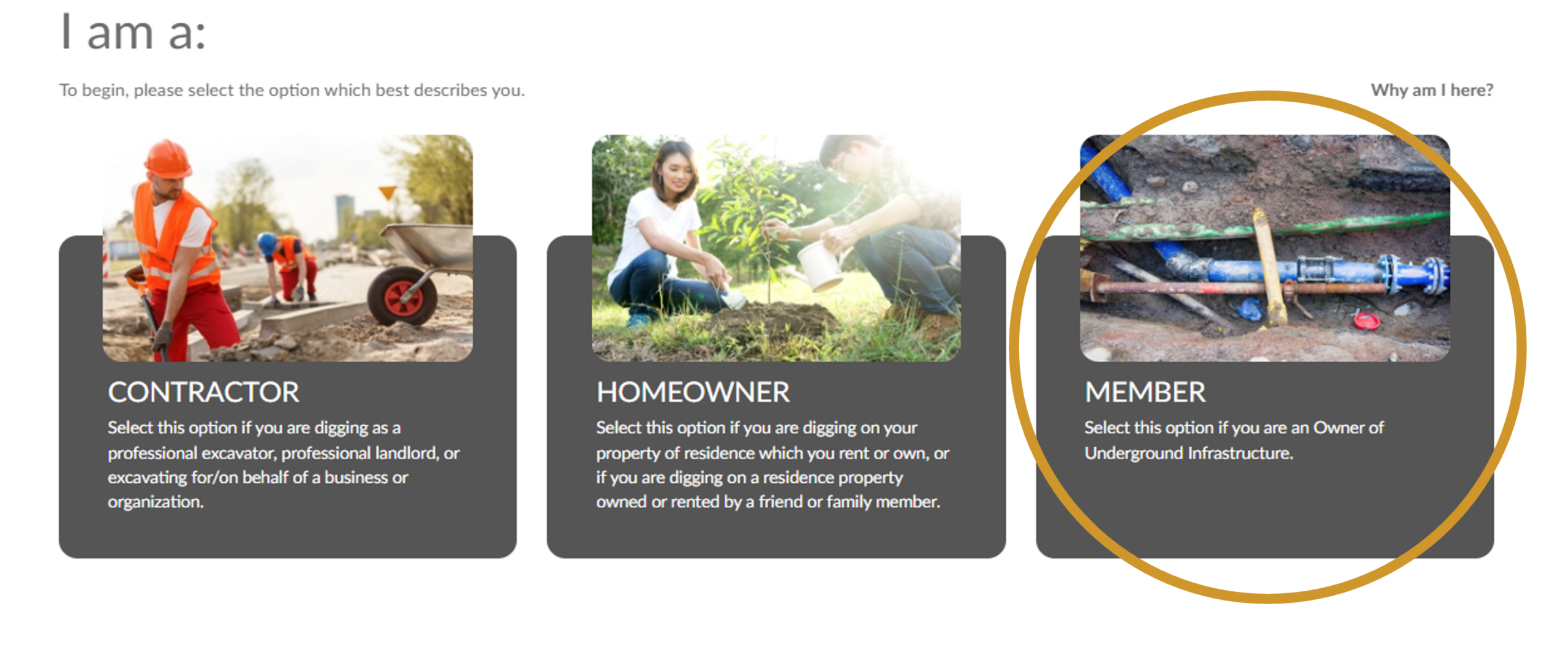
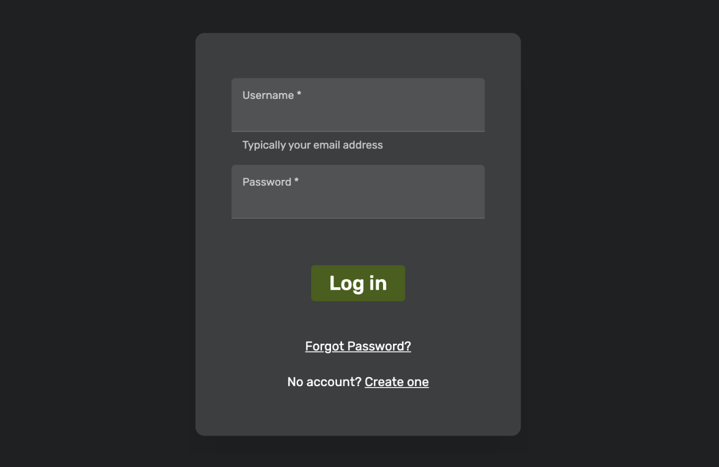
Login using the member link on our website
Step 2:
Click on the search field.

Step 3:
Toggle to Advanced Search.
Step 4:
Search for a time period, such as “Last month,” or select a custom date range. You can search up to six months at a time.

Step 5:
Input the Station Code in the Station code field and then click search.

Step 6:
Click on expand list.
Step 7:
Click Export with Details (lower right hand of the page).

Within the spreadsheet in column AA the locate status will indicate if the request has been updated with a response.
Column AD will display the closed date (please note that if no closed date is entered, even if the locate response was delivered within the legislated timeframe, it will not register as compliant).
Column AE displays the date and time of the last update.
It is recommended to sort by locate status for those which are not cleared or completed. If cleared/completed statuses are present, a secondary screen for whether a closed date was entered is encouraged.
Finding a UIO’s Contact Information Within the Web Portal
You may need to contact an Underground Infrastructure Owner (UIO) or their Locate Service Provider (LSP) for multiple reasons, including:
- Questions about a locate response or locate delivery, including late locates. If your locate response is late, please contact the UIO or their LSP first. UIOs have until the end of the 5th day for single civic address requests and until the end of the 10th day for advanced requests to respond.
- Give additional instructions.
- Renegotiate a new legal date for a UIO to respond to your request.
Where to Find Information
- Log into the Web Portal and use the search bar to look for your locate request. You can log in here.
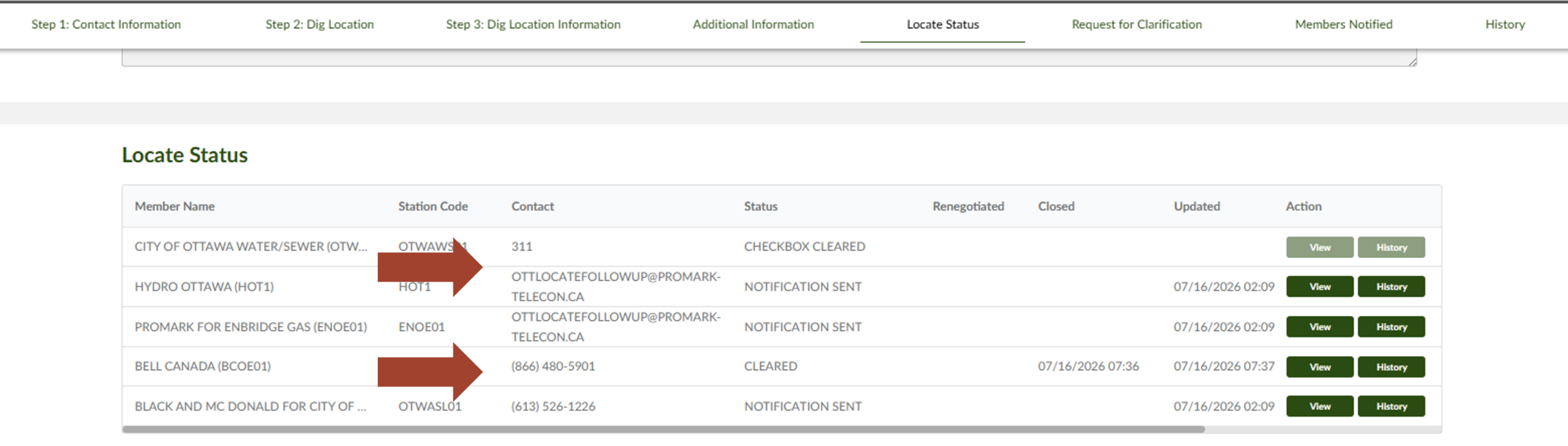
- Once you have located the request, open it and click on “Locate Status”. The Locate Service Providers and the owners of the buried pipes and cables (UIO) will be listed under “Member Name”. On the same row, you will find the Station Code and Status.
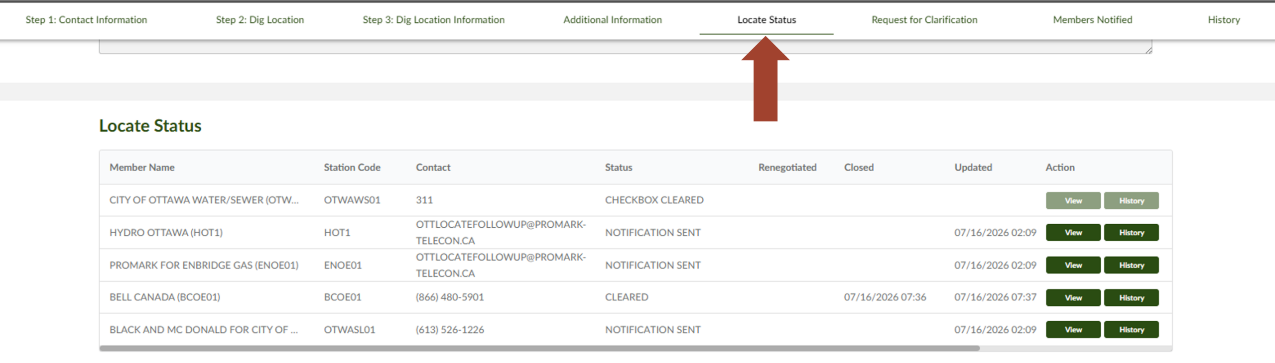 If the status is “completed” or “cleared”, please check the email you provided when making your locate request. The UIO will likely have sent the necessary paperwork to this address. Checking your spam or trash folder is also a good idea.
If not, please contact the LSP or the UIO directly.
- The contact information for each UIO or LSP can be found in the “Contact” column. If you are experiencing issues with the Web Portal, please contact us.
Finding Open Locate Requests in 360 Feedback
Sometimes, as an Underground Infrastructure Owner (UIO), you need to find all requests that have not been actioned in 360 Feedback. This may be because you’re starting to update requests or you’re checking to see if you’ve missed something.
Either way, this How-To Guide will help you find all open requests in 360 Feedback.
How To Do This
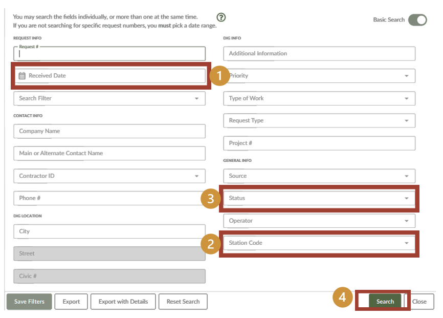
In the Web Portal, click on the search option, toggle Advanced Mode on.
- Change the Locate Status to ‘Notification Sent’
- Change the Station Code to your station code(s)
- Change the ‘Received Date’ to the date range (up to 30 days) that you wish to view requests
- Click Search and view your results
The image below is a screenshot of how your Advanced Search should look like and what fields to fill in.
Remember
UIOs and excavators can search for requests 6 months at a time.
By law, UIOs must update 360 Feedback within 3 days after completing a locate response.
Legal Response Timelines for UIOs
Every Underground Infrastructure Owner (UIOs) has a legal obligation to respond to locate requests from excavators. The legal timeframe for a response is dictated by the type of request.
UIOs also have a legal obligation to inform the Ontario Dig Authority that they have completed their locate response. This is accomplished by a web-based solution provided by the Ontario Dig Authority called “360 Feedback”.
360 Feedback can also be used by the excavator who has made the locate request to check the status of their request and to find contact information for UIOs or their Locate Service Providers.
5 Business Days – Single Civic Address Locate Requests
UIOs are required to respond to Single Civic address locate requests by the end of the 5th business day after receiving the notification.
Ontario Underground Infrastructure Notification Systems Act (The Act) refers to this as a standard notification.
S.6 (3) of The Act
10 Business Days – Advanced Locate Requests
UIOs are required to respond to Advanced locate requests by the end of the 10th business day after receiving the notification.
Advanced requests refer to large excavation or dig sites defined as:
- at least two properties or parts of properties, each having its own municipal address, or
- one or more properties or parts of properties, at least one of which has no municipal address.
O Reg 136/24
2 Hours – Emergency Locate Requests
UIOs are required to have a person on-site to respond to the emergency request or provide a clearance within 2 hours.
S.6 (4) of the Act
10 Business Days – Dedicated Locator Requests
The Dedicated Locator Service Provider is required to respond to a locate request within 10 business days of receiving the Dedicated Locator notification.
S.7 (10) of the Act
3 Business Days – Update 360 Feedback
In ALL cases, Unground Infrastructure Owners must provide an update to 360 Feedback within 3 business days of responding to the locate request.
S.14 (1) of the Act
Benefits of Updating 360 Feedback
It can help track locator performance, both for the internal staff and/or for the Locate Service Providers completing responses on your behalf.
Benefits include:
- It can de-escalate suspected late-locate response situations
- It can reduce reach-outs and follow-up calls
- It can notify the Ontario Dig Authority of a Locate Delay
- It can display the new due date for a renegotiated request
- It can help track locator performance, both internal staff and/or Locate Service Providers completing responses on your behalf.
Locate Status Definitions
- Notification Sent
- The Ontario Dig Authority has notified the underground infrastructure owner (UIO) of this locate request.
- Sent To Locator
- The notification has been sent to the UIOs locate department or their locate service provider (LSP) to complete a physical locate.
- Check Box Cleared
- The UIO has indicated that, based on the information you provided, they do not believe your excavation poses a threat to their underground infrastructure. You will not receive any additional paperwork.
- Cleared
- The UIO has indicated that a physical locate is not required; you should receive clearance paperwork from the UIO or LSP.
- Completed
- The UIO or LSP has physically marked the dig area with paint and/or flags to show where the infrastructure is present. You will receive paperwork from this UIO/LSP.
- Not Completed
- The UIO or LSP has not completed this request. Please contact UIO/LSP for more information.
- Requestor Must Provide More Info
- The UIO would like the excavator to provide additional information.
- Contact Member
- The UIO would like to be contacted by the excavator.
- Cleared By Relocate Delay
- The UIO has indicated that the locate is still valid and you are to follow the information provided on the previous locate response.
- Suppressed
- Suppressions are used by UIOs on their own infrastructure. Since they are both excavator and UIO, no notification will be sent. You will not receive any additional paperwork.
- Renegotiated
- The excavator has agreed in writing to a renegotiated date with the UIO.
Mandatory Fields in 360 Feedback
360 Feedback is the Ontario Dig Authority’s web-based solution used by UIO to report the status of their locate response and by excavators to check the status of their request and find contact information for UIOs and Locate Service Providers.
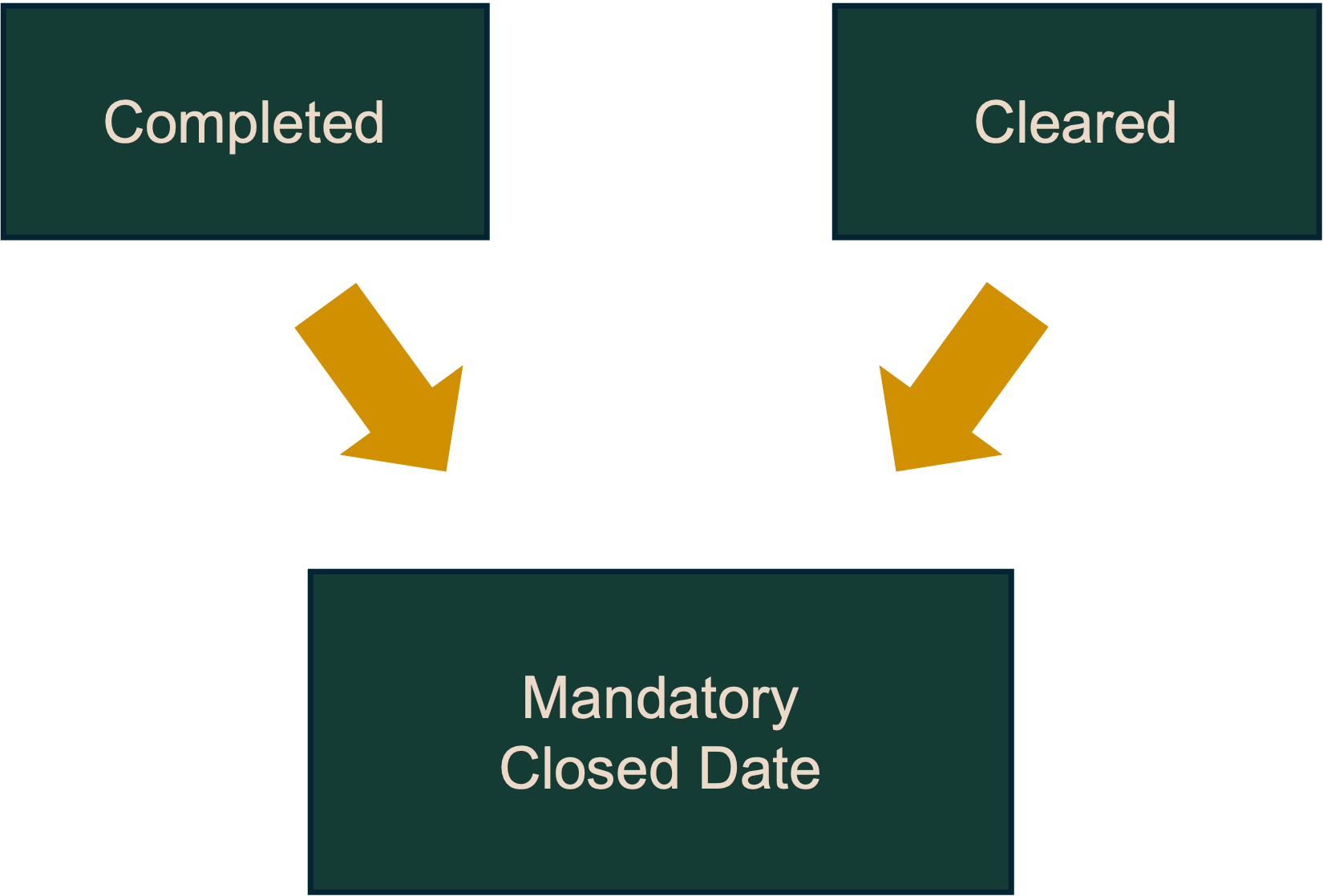
When Underground Infrastructure Owners use Ontario Dig Authority’s 360 Feedback to update their locate status, there are specific mandatory fields. A closed date is required for every locate request to ensure compliance. The Notes field is required in certain instances.
Closed Date
- An accurate Closed Date is mandatory once a locate response has been finalized. The closed date should be the date the paperwork was provided to the excavator.
- Failing to include a Closed Date will not prompt the Ontario Dig Authority system to stop the clock and it keeps counting the days.
- If there’s no closed date at the end of the legal timeline, the response will be considered “noncompliant no response” even if a locate response has been provided to the excavator.
Notes Field
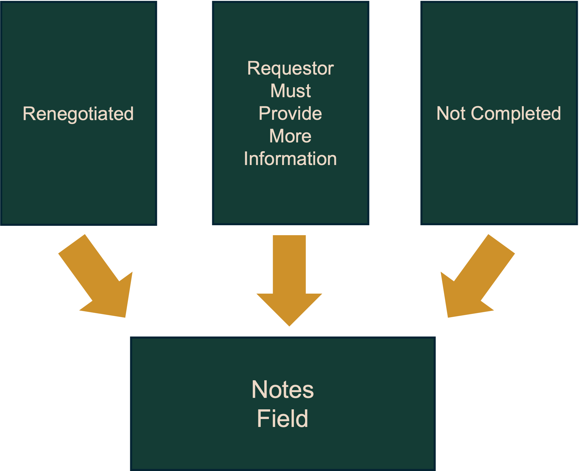
Use the Notes field to document any communication with the excavator or anything abnormal about a locate response. This is vital if the locate status is being changed to Not Complete or Requestor Must Provide More Information.
If a locate request is renegotiated, the Notes field is mandatory.
Some examples: if a locate request was Renegotiated, the notes field might read, “New due date of November 1, approved in writing by Karolina Black, project lead.”
Or “Left message on November 15 for Steve to clarify dig location” if the status was changed to Requestor Must Provide More Information.
Or “Broken tracer wire. Will repair on November 8” for Not Completed
Remember:
Only Cleared and Completed are compliant statuses. Use of these statuses does not fulfill your legal obligations; further action will be required.
New Subdivisions
Certain locations require a detailed description explaining the distance and direction to the dig area from the nearest visible or existing intersection. Your request will suspend when there is a discrepancy or incomplete information such as; incorrectly or un-labeled streets, the satellite map shows an empty field and/or the new street name does not populate within the Address Search list.
Why You Want to do This
You know the proposed work area best! Our Customer Support team reviews suspended requests to compare the Map selection(s), Dig Locations and Dig Information submitted. If a Support Specialist finds a discrepancy, they will send a clarification email from “donotreply@OntarioDigAuthority.ca” requesting more information and/or a change to ensure you have valid locate paperwork.
Who Can Help Fix My Mapping Issues
We are continuously making improvements to our online service and value your feedback. If you have any questions or would like to provide us with mapping feedback for streets that do not populate in the menu, appear on our maps, or you have found an error, please contact us and include any GIS maps or Developer Site Plans you may have.
Where You Can Find Resources
- Local Municipality GIS maps
- Developer’s plans
- Your crew onsite
- Ontario Dig Authority Support Services
Our Recommended Process When a Street Does Not Appear on the Satellite Map
- Reference the local Municipal GIS map
- Select “Advanced Request” type. If the “street” name is not available in the Address Search menu, enter the City name and/or closest known intersection to your proposed dig area; this will load the satellite map.
- Use the web portal measuring tool, approximate civic pin drop, and street view tool to aid with creating an accurate map selection.
- Draw a shape around your proposed dig area; you may need to draw a larger map selection depending on the information you have.
- “Review Your Address” and if the new civic and/or street is not an available option, manually type in and select the City name where the proposed work will be occurring.
- **IMPORTANT STEP** If the “Review Your Address” does not appear, click on the map selection and use the ‘edit address’ to select the city name only.
- Create your “Map Selection Label” and “Name” the “new” street you are working on and Attach your map selection.
- **IMPORTANT STEP** “Confirm your Dig Location” and ensure the information is correct; Your map selections should be on or parallel to the “Dig Street” and the map selection(s) should be between the two closest intersecting streets provided – use the new “Dig Street” and “Intersection” names where the excavation is actually taking place.
- **IMPORTANT STEP** Include a description indicating this is a new subdivision (i.e. New street located N of Ontario Rd and E of One Call St.)
- Provide the Underground Infrastructure Owner with more information by attaching any new subdivision site/developer plans you may have in “Your Additional Sketches”.
Notice of Delay – Response to Locate Request
What you need to know
As per OUINS Act Section 14 (2), If an Infrastructure Owner or Dedicated Locator becomes aware that there will be a delay in providing a locate, they must notify Ontario Dig Authority of the expected delay as soon as possible.
How to do this
An Infrastructure Owner or its designate (Locate Service Provider) will need to enter a note in 360 Feedback for the affected request. The note must state that the locate response will be late (beyond the legislated timeframe), and when the locate response is anticipated to be completed.
Important
Notifying Ontario Dig Authority is not a renegotiation* and does not change the legal timeframe to complete a locate, nor does it absolve the Infrastructure Owner from Compliance actions for not meeting the legislated frame, or other breaches of the Act.
*Renegotiation involves a written offer and an agreement between the Excavator and Infrastructure Owner.
For more information contact us.
Performing Corrections and Updates
Excavators can make a change to their request after it has been processed, but prior to the work to begin date as stated on the request. Depending on the information that is being revised the system will perform a correction or an update.
Corrections
The system will perform a “correction” when you only make changes to the Contact Information section of a locate request. The request number will remain the same when a correction is made.
Updates
If any information in the Map Selection or Dig Location Information sections is changed, the existing locate request will be cancelled. The system will then create an updated locate request with a new request number.
How To Perform A Correction/Update
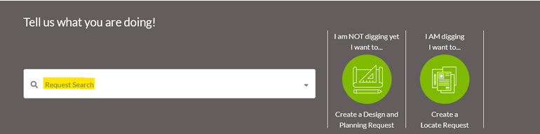
- Begin by searching for the request number you would like to correct/update using the “Request Search” bar found on the homepage the Web Portal.
- Click on the green request number that needs editing in the sidebar on the left side of the page.
- Select “Edit Request” at the top of the locate and click “Correction” from the menu that appears.
- The web portal will now reopen your request and you can make your changes as required.
- Once you are finished making your adjustments scroll to the bottom of the request and then click on “Next Step Review”.
- Once you have reviewed your changes click on “Submit My Request” to process the changes with Ontario Dig Authority.
Reasons Why The Edit Button May Not Be Available
- Excavators cannot make changes to requests that have not been processed. This includes requests that are suspended for review or are in Long Term Suspend.
- Tickets cannot be amended after the work-to-begin date. UIOs are expected to have provided a response by this date and, therefore, the parameters cannot be changed.
- If you are experiencing issues with the Web Portal, please reach out to: LocateRequests@OntarioDigAuthority.ca
Relocates
As the Notification System, the Ontario Dig Authority does not schedule, or complete physical locates. Locate Documentation and Clearances are sent directly to excavators. Locate Responses are valid for at least 60 days, but Underground Infrastructure Owners (UIOs) may decide to increase the validity based on their risk tolerance.
To ensure proper notification, the Ontario Dig Authority advises excavators to submit a relocate request 10 business days before the earliest locate response expires, based on the validity noted on each UIO’s locate response.
Following this How-to Guide ensures the Locate Request Confirmation lists the “Members Notified” when required and shows the “Existing Locate Still Valid” status when applicable.
What You Need To Know
- Providing more accurate information, including a description of the dig area with distance/direction from a geographical reference, improves the efficiency and accuracy of completed locates.
- Refer to the locate documentation/clearance paperwork you receive on behalf of each UIO for the validity and/or expiration. Relocate a request before the earliest locate expires.
- You are required to have a copy of the locate request confirmation from the Ontario Dig Authority on-site with you; including the previous locate responses for any UIO that provided “Existing Locate Still Valid” as the initial status on your current request.
- Changes to the dig location/information are not permitted when submitting a relocate. Requesting locates for an area larger than you require may cause delays, as UIOs are not obligated to complete locate responses when the work is not going to commence, over the entire area you have requested, within 60 days.
- Requesting a relocate to try and resolve a late locate issue is not an effective method as it often results in notification issues. If your locates are late, please consult our Compliance and Industry Performance webpage.
Relocating Single Address Requests
By law, single civic address requests must be completed by the end of the 5th business day.
To ensure proper notification, the Ontario Dig Authority advises excavators to submit a relocate 5 business days before the earliest locate expires, based on the validity noted on the locate response.
Relocating Advanced Requests
An Advanced Request refer to a large excavation or dig site defined as:
- at least two properties or parts of properties, each having its own municipal address, or
- one or more properties or parts of properties, at least one of which has no municipal address.
When you request a relocate and ‘Existing locate still valid’ appears in the Initial Status section of the Locate Request Confirmation, the UIO has a Relocate Delay indicating to the Ontario Dig Authority that their previous locate response is still valid. However, it is your responsibility as an excavator to ensure the locate paperwork you received directly from each UIO or their Locate Service Provider (LSP) is in fact still valid.
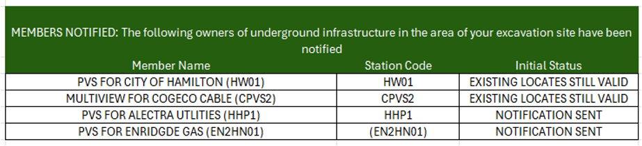
In the example below, on the first relocate request of the original locate, the Electrical and Gas UIOs do not have a Relocate Delay, so their initial status is ‘Notification Sent’. The Communications and Municipal members have a Relocate Delay, and ‘Existing Locate still Valid’ appears in the initial status.

Review
Review the paperwork you received from the UIO (or LSP) for the first Locate Response to ensure it is valid. Include those original locate responses with the new Ontario Dig Authority Confirmation, which shows the “Existing locate still valid” status.
Wait for a response from any UIO with this status and add them to the locate package.
Who Do You Contact With a Relocate Issue?
Check the “Members Notified” list on the locate request confirmation email. Reach out to the UIO directly to request an extension on the most recent locate response from this UIO.
Contact Infrastructure Account Services for further assistance.
Our Recommended Process For Managing Relocates
- Request locates that are appropriate for the scope of your work. Consider the size of the project, the length of time it will take your team to complete the work and request a suitable area.
- Include an ‘Estimated completion date’ on long term projects.
- When your work will not be completed within 60 days, review the most recent responses you received from each member/LSP and 5 (for a Single Address request) or 10 (for an Advanced Request) business days before the earliest locate expires depending on the kind of request (single address or advanced).
- Confirm none of the dig location/information details have changed since the previous request.
- Ensure the contact details are correct; you may change the main contact’s name, phone number and email address when requesting a relocate online.
- Review the Ontario Dig Authority Locate Request Confirmation email for any UIO with an Initial Status of ‘Existing locate still valid’ and keep the previous locate paperwork onsite to ensure you have a valid response from each UIO.
- Track late locates separately from Notifications, and action late locates in a timely manner. To submit a complaint for late locates, please consult our Compliance and Industry Performance webpage.
- When a UIO has not responded within 5 business days for a standard request or 10 for an Advanced Request, their locate responses may fall out of sync with the other UIOs that have responded. When this occurs, please contact the UIO directly and ask for an extension on the most recent locate response you received to try and synchronize the paperwork moving forward.
- Please contact Infrastructure Account Services for further assistance.
Renegotiation
A renegotiated date changes the legal timeframe for an Underground Infrastructure Owner (UIO) to complete a locate response.
If a renegotiated date is agreed to, the UIO now has until the new agreed-upon date to complete the locate response, not the original date on the request. This new date needs to be beneficial for both the Excavator and the UIO.
Excavators do not have to accept an offer to renegotiate a new date. If a UIO, or their Locate Service Provider (LSP), tells an Excavator that a locate will be late, the Excavator does not have to agree to change the legal due date for the delivery.
Important
To stay compliant, both parties need to know the intention of the agreement – to change the legal due date of a locate delivery – and Members need to make sure there is a written offer and a written acceptance before changing the status in 360 feedback.
How To Do This In 360 Feedback
After agreeing in writing to a new date with an Excavator, the UIO must input the information into 360 Feedback.
To change the renegotiation date, a UIO is required to do the following in 360 Feedback:
- Change the locate status to renegotiated
- Enter the renegotiation date
- Enter details of the renegotiation in the notes field
Misuse
A renegotiation date changes the legal timeframe for a locate response, and it must not be misused.
Entering a false renegotiation date or lacking written evidence of an offer to change the date and its acceptance is a breach of the OUINS Act and could result in Compliance action.
Items To Consider When Renegotiation
- If a UIO is planning to renegotiate, it should do so before the designated 2 hours for an emergency locate, 5 business days for a standard locate, or 10 business days for a specified or dedicated locate, to avoid being late to respond.
- When renegotiating, the offer to change the legal due date and the acceptance between the parties must be in writing. Both parties must understand that this will change the legal due date of a locate response. It is highly recommended that the written offer explicitly states this intention.
- When providing the required notes, include details surrounding the renegotiation. For example: your name, who agreed in writing to the new date, what date they agreed to, and the date you spoke to them.
- If you need to renegotiate a locate response multiple times, make sure each has a written agreement, and 360 Feedback has notes that includes the details of each renegotiation.
Use of Renegotiation
- Renegotiating a locate request means the locate due date is being changed
- Great for large projects. Sections of the locate can be completed as the work progresses.
- The Excavator MUST agree to this change. No exception.
- NOTE: Assigning a renegotiated status without the explicit written approval of the Excavator is considered false reporting and could result in Compliance action.
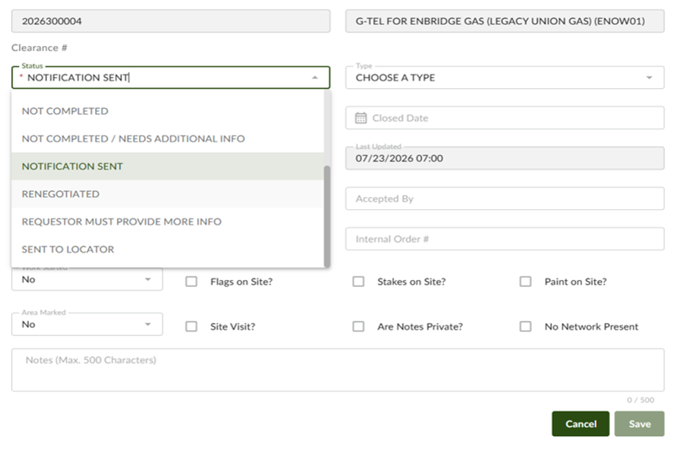
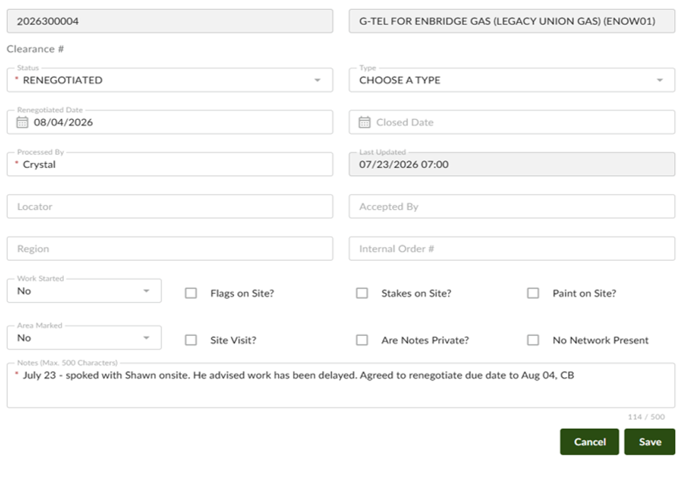
- If the Excavator has agreed to a different locate completion date, this is how that should be indicated in 360 Feedback
Status: Renegotiated
Renegotiated Date: Enter the agreed upon date
Processed By: Add the name of whomever is updating the status - NOTE: Add additional pertinent information that would validate the renegotiation, for example who agreed in writing, and the date the agreement was made
- Save
Remember
Renegotiating of the legal due date of a locate delivery is allowed, providing both parties mutually agree in writing to the new date.
Please Reference:
- Standard and Emergency Requests – OUINS Act Section 6 (5) (a),
- Specified Requests – OUINS Act Section 6 (2) (b), and
- Dedicated Locator Requests – OUINS Act section 7 (11)
Sharing Locate Responses
As per the OUINS Act, an excavator can share locate responses and packages with another excavator, as long as:
- the other excavator’s contact information is included in the locate request, or
- the locate requestor provides Ontario Dig Authority with the other excavator’s contact information
Each company responsible for an excavation needs to have its name associated with the locate responses in the on-site locate packages.
Note that some request statuses, types, and priorities cannot be shared. Only processed locate requests (Single Civic address and Advanced) may be shared.
If you plan to share locate responses and packages with another party, you must choose one of two ways:
Method 1: Included In The Locate Request
You can include additional companies/contacts on an Ontario Dig Authority request within the “Contact Information” section under the “Additional Contact”.
If more room is required, you could put additional contacts into the “Additional Information” section. These two fields should provide enough space to ensure that all the parties working under the locate request are listed on it.
Additional contacts can be added to a request until the work-to-begin date. After the work-to-begin date passes, the excavator who submitted the locate request can no longer change it, including adding additional contact information for sharing locate responses and must use the Locate Request sharing service form. (Method 2)
Method 2: Locate Request Sharing Service
It is best practice to use the Sharing a Locate Request webform found here.
You will be able to use this form at any time after you have created the locate request by following the above link.
Before you access the form, you will need the following information:
- The locate request number.
- The email address used to create the locate request.
- The contractor ID and contact information of all contractors you want to share with.
Why Use Ontario Dig Authority’s Locate Request Sharing Service?
Supports safer digging! Both the person sharing and the person who it was shared with get notified automatically via email with relevant information about the locate request, including:
- Locate request number.
- Locate request details, like max dig depth and tools being used.
Simplified interface is more user friendly.
Responsibilities of The Excavator Who Receives A Shared Locate Package
- Anyone digging must be provided with a complete locate package that they keep with them while on-site. This should include a copy of the members notified list from Ontario Dig Authority so that both parties may ensure that the package is complete.
- Before digging, Excavators must confirm that all locates are complete, valid and within the same dig parameters as the locate request and have verified that the markings on the ground match the locate paperwork – OUINS Act, Section 10 (1) & (2). The dig parameter information is included in the email.
- Dig Safely – An excavator shall not excavate or dig in a manner that the excavator knows or reasonably ought to know would damage or otherwise interfere with any underground infrastructure – OUINS Act, Section 13.
Undefined vs. Defined Mapping Coverage
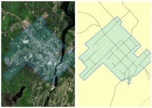
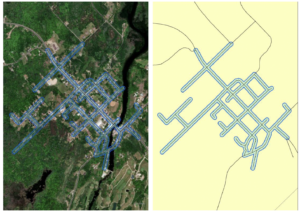
In December 2017, the Ontario Dig Authority changed the way in which we notify Underground Infrastructure Owners (UIOs) from street segments to map selections. The new map selection-based notification system takes the map selection made by the excavator or Ontario Dig Authority agent and compares it to the coverage our UIOs have provided.
If the two overlap, the UIO will be notified and if they do not overlap, the UIO will not be notified.
This has increased the accuracy of notifications considerably, resulting in a reduction of unnecessary notifications. However, this reduction can only be achieved if the UIO provides accurate, defined mapping.
Undefined Mapping
The UIO will receive every request within the blue hatched area.
Defined Mapping
UIO has mapping coverage only where they have infrastructure and will receive requests only if the map selection overlaps their mapping coverage.
Why Do You Want to Do This?
By having a defined notification coverage, you reduce your overall notifications; reducing the number of nuisance clears and unnecessary emergency calls makes it easier to maintain compliance with the OUINS Act.
Further, the information submitted in a request is now of a higher degree of accuracy. This, in turn, has helped reduce the number of damages due to incorrect notification information.
How to Make Changes
Improvements can be sent to Ontario Dig Authority in stages. Start by removing what you do not require a notification for.
This could be:
- An area where you have no service coverage
- Areas where you have no underground infrastructure
- Areas where you have only overhead infrastructure
You are able to add any value buffer around your infrastructure but remember that the Ontario Dig Authority adds a 10-meter safety buffer to all map selections to account for any map drift or human error.
Using The Confirmation Page To Help Track Validity
REMEMBER:
You MUST NOT dig until ALL Underground Infrastructure Owners (UIOs) have provided a cleared or completed response to your locate request.
What You Need To Know
A complete locate package is an essential document to be kept at an excavation site. It contains important safety information that will help protect your crew.
What Is Included In A Complete Locate Package?
- The Ontario Dig Authority confirmation page
- A response from every Underground Infrastructure Owner notified
- Responses from any other sources
- Any other relevant information (emergency contacts if buried cables/pipes are found and were not on the locate, specific safety protocols, company Best Practices)
Sharing Locates
If you plan to share your locate package with another excavator or subcontractor, it is best to include their contact information when you submit your locate request.
You can include an additional company/contact when making the Ontario Dig Authority request within the “Contact Information” section under the “Additional Contact”.
Learn more about sharing locates.
Who Should Have Access To The Locate Package?
Whoever is operating the digging equipment and the foreman should have a copy of the complete locate package.
Locate Response Validity Period
By law, all locate responses must be valid for a minimum of 60 days.
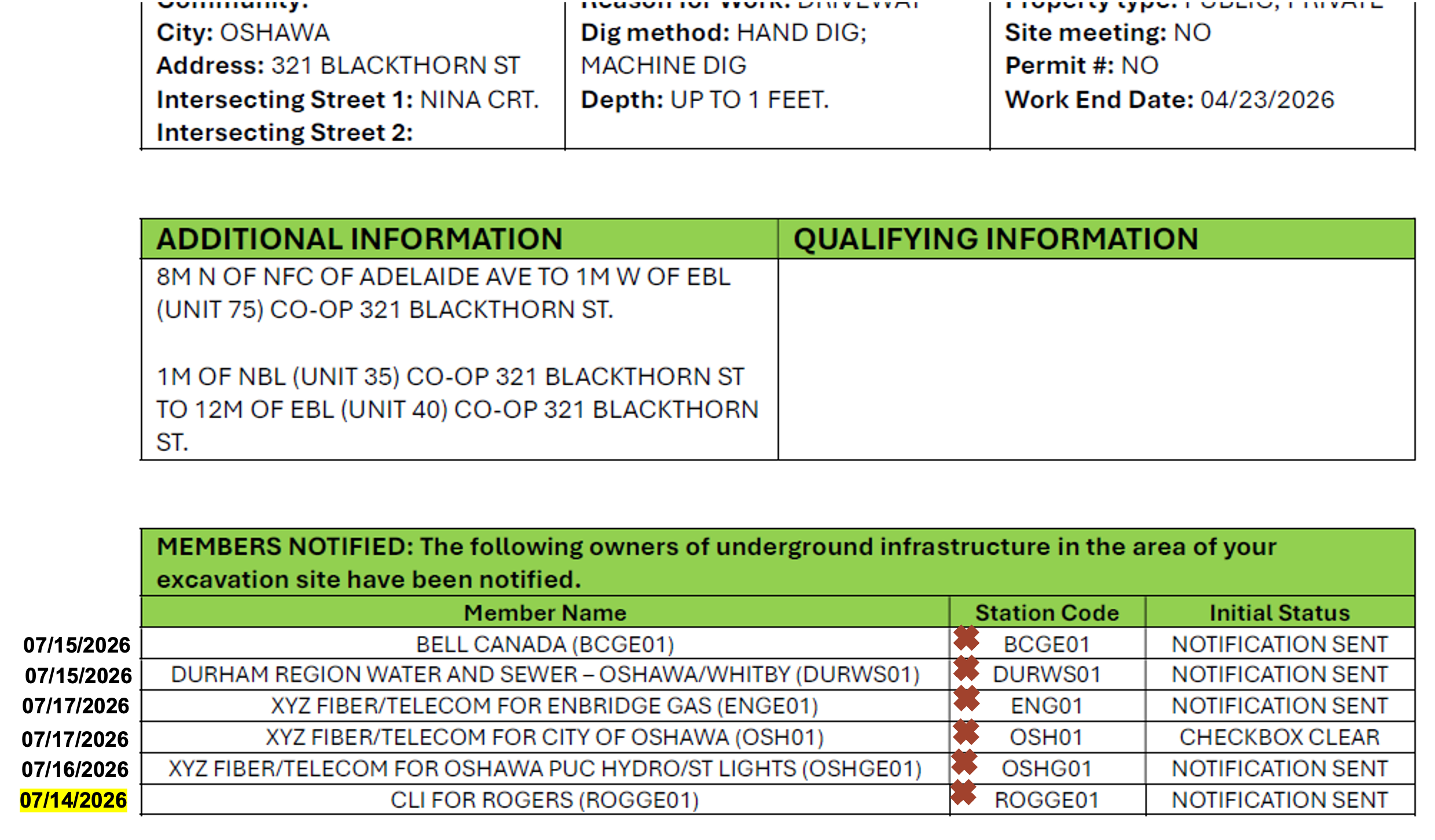
Use the Ontario Dig Authority Confirmation Page To Help Track The Validity of Locate Responses
Step 1:
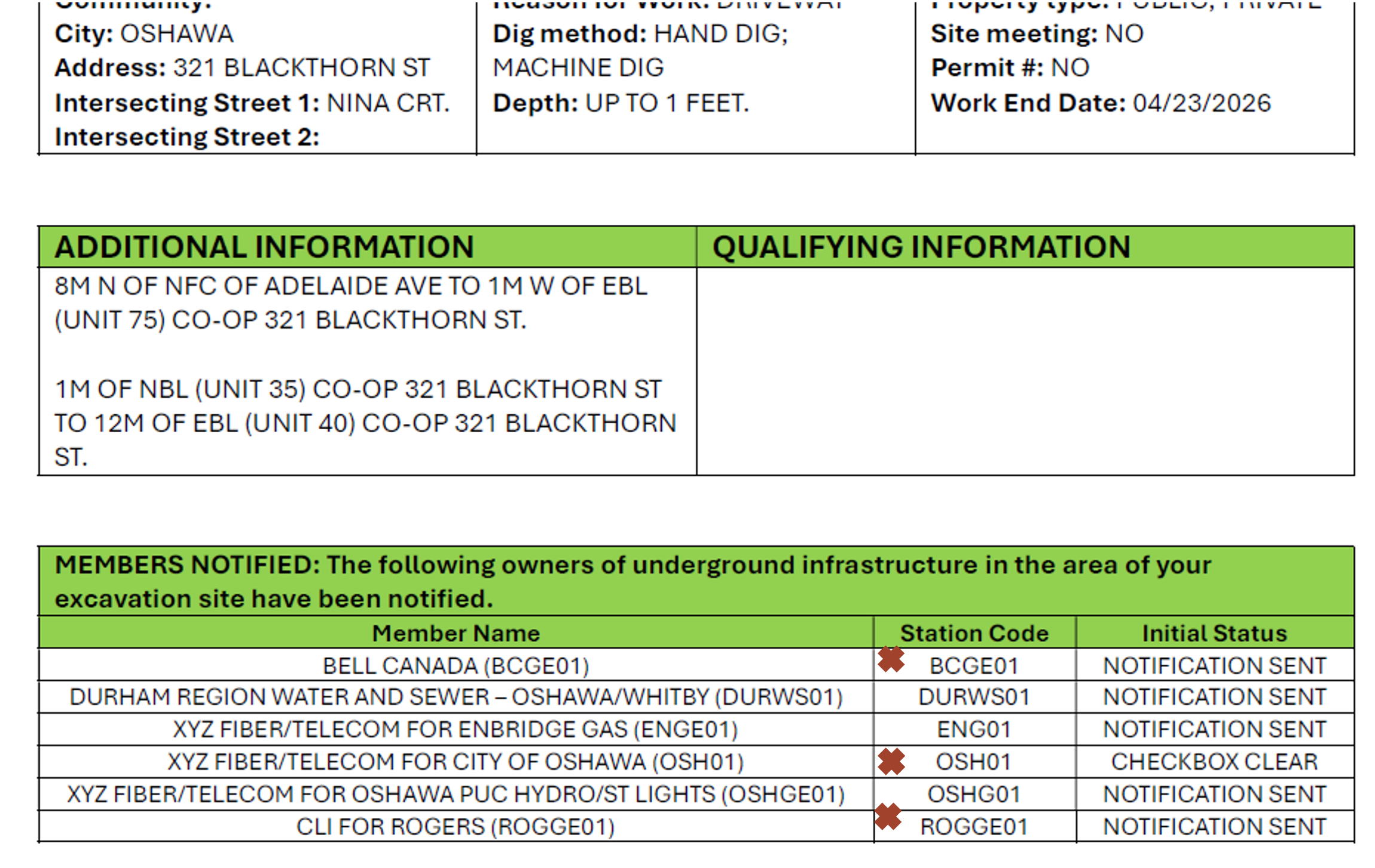
Each time you get a response from a UIO, mark it on the Ontario Dig Authority confirmation page.
Step 2:
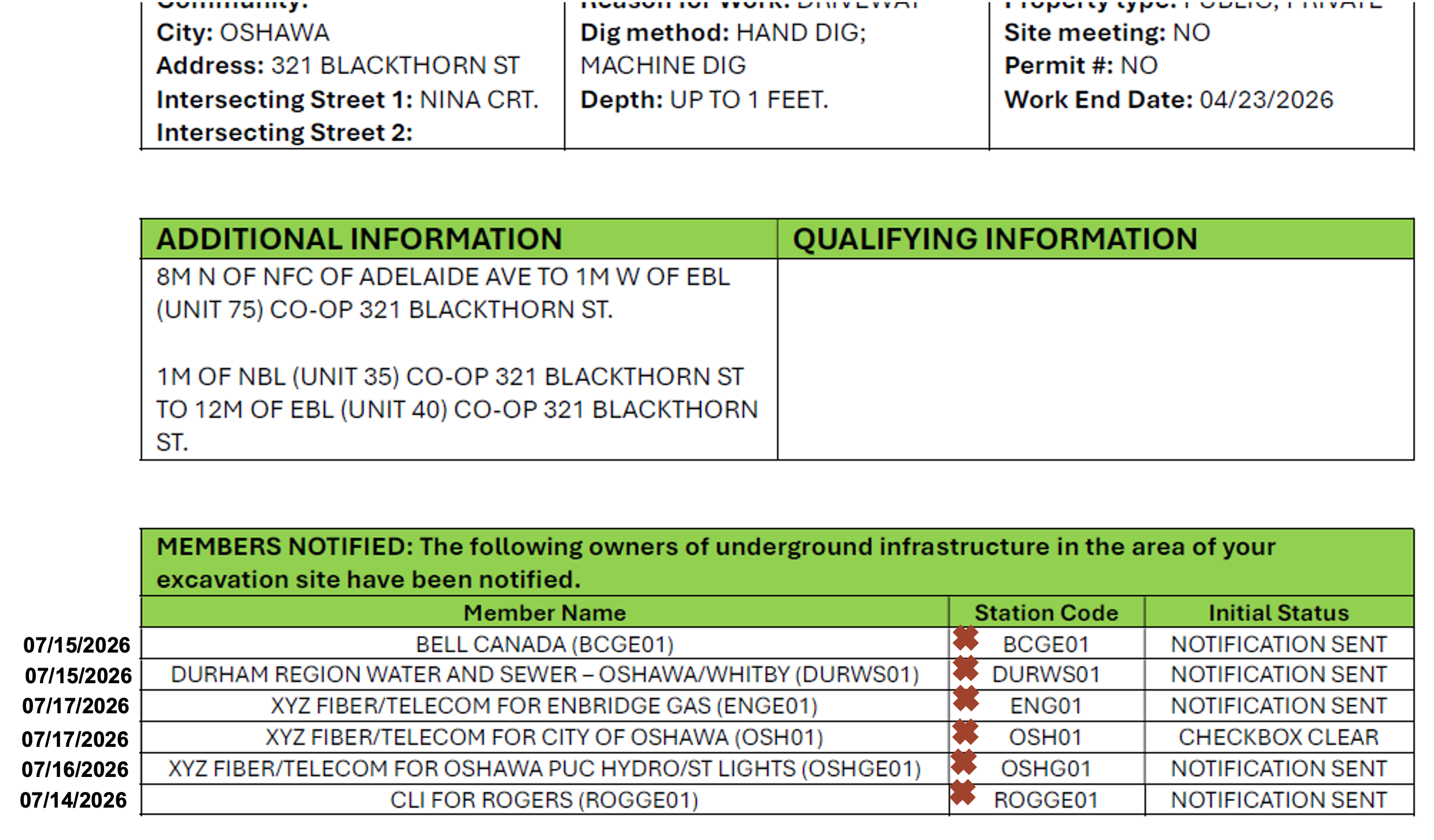
Note the expiration date beside each UIO’s name.
Step 3:
Highlight the earliest expiry date.
Now you know when your locate package expires.
Do not continue digging past this date without making a new locate request or submitting a relocate request.
Verifying Dig Locations
Notification to the Underground Infrastructure Owners (UIOs) is based on the drawing(s) an excavator creates on the aerial map during the locate request process.
The map selection within the locate request is based on the information entered in the Address Search bar.
To aid with verifying a location, the system may suggest a civic location using a pin drop and/or civic number on the map, however, these are approximate and should be confirmed for accuracy. The web portal’s aerial map includes a measuring tool and a street view tool to help you find the correct work location. You should consult another map source and/or gather more information from your client if you are unable to confidently identify the dig area on the aerial map.
The system compares the Address Search information you enter to the map selection(s) created, and when there is a discrepancy, you will be asked to “Review Your Address”.
Single Civic Address Requests
“Review Your Address” will only allow you to select one address. Confirm your work area and select the correct address.
If you find your work is spanning multiple addresses, you must submit a separate request for each civic or use the Advanced Request type.
Verifying your location is important because you may not have personal knowledge of the area, and selecting the wrong location may lead to invalid locates responses, injury to you or your crew, and damage to infrastructure.
Advanced Requests
“Review Your Address” will allow you to select one or more addresses.
Confirm your work area and select the correct option: current address, map selection address, Multiple civic addresses, or Edit Civics, address, map selection address, Multiple civic address, or Edit Civics. Edit Civics allows you to add or remove civic addresses.
Our Recommended Process For Verifying A Dig Location
- Select Single Civic Request or Advanced Request. Please note, if you select Single Civic Request and your work spans more than one civic, the request will suspend for review, and you will be asked to create a new “Advanced Request” type.
- Start typing the civic addresses and/or Street name (for Advanced Request only) into the Address Search and carefully select an option from the menu.
- Use the Google Streetview tool to familiarize yourself with the location and confirm the approximate pin dropped on the correct civic address provided.

- Use the measuring tool to identify the proper work location for your team and the locators.
- If you cannot verify the location on the aerial image based on your personal knowledge of the location, use another reference such as a Municipal GIS Map or gather more information from someone who has been onsite.
- When required:
“Review Your Address” and select all civic addresses where the proposed work will be occurring directly on the lot(s) associated with the civic(s).
“Confirm your Dig Location” and ensure the information is correct. Your map selections should be on or parallel to the “Dig Street” and the map selection(s) should be between the two closest intersecting streets provided
Web Portal Changes – Remarks
EFFECTIVE MARCH 28, 2025
As part of our efforts to enhance the operating process and promote safety, the “remark” option will be removed from our Web Portal as of March 28, 2025.
This change ensures consistency in locate request procedures and is in accordance with the requirements of the Act.
It was also informed by industry feedback, collected by engaging with industry representatives to gather insights and guidance on this change. Their input helped shape our approach to ensure the transition is practical and beneficial for all stakeholders.
REMINDER:
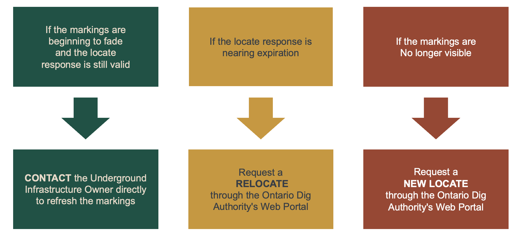
Continuing to dig when markings are no longer visible is considered digging without a locate